Understanding how rainfall, flooding, tsunamis, even lava flow alter the surface of the earth just got easier for geography students. Titans are getting a hands-on lesson in how Cal State Fullerton teaches differently in its classes this fall.
Greg Beringer ’16 (B.A. geography), a graduate student studying geography, encouraged students at summer orientation to get their hands dirty as he demonstrated an augmented reality sandbox he built in spring. The portable sandbox debuts in geography classrooms this month, after receiving oohs and aahs usually reserved for summer fireworks.
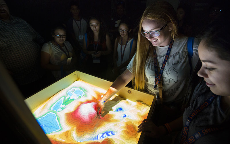
“I like to call it a living topographic map,” Beringer told the cluster of new students circling the sandbox. “Push the mountain over. You’ll see what happens when you have a landslide or a volcano blow (its) top off,” he said prompting students to reach into the sand. “Go ahead, shove it over.”
Like icing makes a cake irresistible to a toddler, Beringer’s sandbox brings field study to the classroom. The touchable tool replicates a topographical map and makes tough concepts like geomorphology and hydrology — usually confined to a two-dimensional textbook — as simple as playing in sand.
Dig a pit in the sand and a channel becomes a canyon. Hover a hand over the top and make it rain. Shove the sand pile aside and the water shifts to create a tsunami.
With the press of a button, Beringer floods the newly formed sandscape.“ This is what I like to call Houston, Texas, last month,” he said with a laugh, during a summer presentation. True, Texas got a lot of rain in a short amount of time. And when California’s El Niño was a no-show in spring, it looked like the dry valley Beringer exposed with another touch.
The augmented reality sandbox was designed by researchers at UC Davis last year. It uses first-generation Kinect, a short-throw projector, open-source software and a laptop computer to transform 150 pounds of white sand into a 3-D image. A camera collects the image. The software creates color and contour lines that are projected back onto the sand, showing elevation of sea and soil levels, as well as flooding and water patterns.
The sandbox can be used to study rainfall and flooding, and to predict the effects of storms like El Niño, even lava flow. It will be used to illustrate lessons in spatial data courses and Beringer will soon demonstrate the sandbox to faculty who teach the Introduction to the Natural Environment classes.
It could be the connection point for students who get their first view of geography in a general education course, said Zia Salim, assistant professor of geography.
“By bringing the content and the technical skills together in a really fun and interactive way, we can radically improve the understanding of a student in our Geography 110, Intro to Natural Environment course who’s studying, say, a freshwater ecosystem, or a mountain range,” he said.
“Knowing how to read a topographic map isn’t some esoteric skill,” Salim said. “From engineers to hikers, to environmental managers to the military, being able to look at a 2-D map and, in your mind’s eye, see the lay of the land is an immensely useful skill. I’ve even seen examples from history, where historians use these maps to understand the how and why of troop movements during Civil War battles.”
John Carroll, director of the campus GIS Research Center, interim director of academic technology, and Beringer’s mentor on the project, said using the sandbox for outreach will raise awareness about the CSUF Geography Department. “Many people are unaware that geography is an exciting major with great job opportunities for graduates,” he said.
Beringer’s sandbox was one of six CSUF geography activities at the Orange Unified School District’s 11th annual Community Science Night in March. He’s also slated to share the sandbox at community outreach and educational events in Irvine, Long Beach and Costa Mesa.
The student-driven project is a natural recruitment tool, Salim said.
“As a student, you might not be completely aware of what you are capable of, or you don’t know what kinds of research resources exist beyond the classroom,” he said. “So, we think it is very awesome and very inspiring for students to see what another undergraduate student just like them was able to accomplish.”
Related story: Beringer’s Cartography Project Wins Third Prize